LUXOR MAP:
SafariEgypt has acquired a huge collection of Maps
that will be displayed starting Jan 2007. The new collection
will include all destinations, cities and tourist attractions
referenced in this website. We are now showing maps for
the main cities of Egypt.
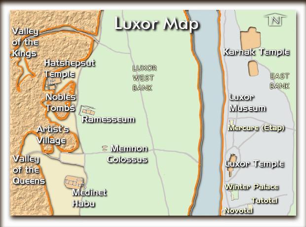
Luxor City is located on the East bank of the Nile, and here nearly
all hotels are found together with the temples at Karnak, beautiful
Luxor Museum and the Luxor temple in the middle of town.
On the West bank the Royal Valley of Kings and Queens, temples as
Hatshepsut terrace temple, Medinet Habu with its three temples
(Hatshepsut and ThotMoses III, Ramses III and two priestesses ruling
Luxor in later period). Close to Hatshepsut's temple the remains and
displays from the Middle Kingdom temple of Mentohotep. More temples
as Ramses II temple (Ramesseum) and Seti I temple are also found.
Do not forget the truly unique and beautiful tombs of the Nobles and
in the Artist Village. Here you see scenes from work, home and
parties, and get very close to these people who lived here 3500
years ago.
Yes, do stop by the Memnon Colossus - famous among tourists here
from the Roman Empire and up until today. In fact they are the two
entrance statues that stood in front of AmenHotep III temple. Each
of these statues of the sitting AmenHotep III is still around 20
meters high.
|
|
Copyrighted by SafariEgypt.com
All rights reserved!
All maps, graphics and original descriptions created
by SafariEgypt.com, unless otherwise noted and/or directly
linked to the source, and use of same for any application
whatsoever (with the exception of outline maps) requires
written permission.
We make no copyright claim on any statistical data on this
page, nor on any non-original graphics, and/or pictures
not produced by us. Certain statistical data is gathered
from the locally published maps (authorized and authenticated
by the ministry of Tourism), Google Earth, Google Maps,
CIA World Fact book, as well as numerous public domain reference
materials.
Every effort is made to be as accurate as possible when
disseminating information on any Egyptian destination. We
are not responsible for unintentional data entry errors
or omissions. If you would like to submit an addition, change
or correction, or suggest a new link, please forward it
to our map department (maps@safariegypt.com) and we will
give it our immediate attention.
|


